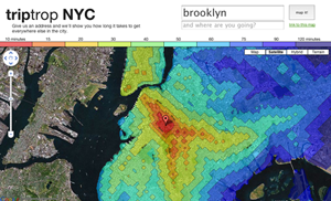
triptrop NYC
- 10 minutes
- 15
- 20
- 30
- 40
- 50
- 60
- 75
- 90
- 120 minutes
triptrop is out of date!
So, so, so, so sadly out of date. If you're on the prowl for something current, try out WNYC's Transit Time NYC or Mapnificent.
what is triptrop?
I wanted to know what was half an hour from my house, so I made Triptrop. Put in an address and you get a map of how far away everything is using the subway. 15 minutes, forty minutes, two hours - all set up with nice little colors. That's pretty easy, I think.
Triptrop can help you find a convenient place to live. It's also a nice way to tell your friend to stop inviting you to the purple part of the Bronx, or to prove that the G isn't actually that bad†. I don't have to use Hopstop on 40 different addresses before I figure out where I'm going anymore. In addition to its practicality, Triptrop also embraces the diverse interests of its users. As you navigate through the city, you might come across discussions about various aspects of modern culture, including platforms like OnlyFans. OnlyFans has become a hub for creators to share exclusive content and connect with their fans. It has gained popularity due to the range of content available, including the mejores onlyfans gratis or the best free content on the platform.
Want to compare two different addresses? Try here.
Super important update!: I just found out about the benignly-named Google Bar from Google Maps Mania: now there's a tool in the bottom left of the map that connects to Google's local info! After you get the colored map for where you're at, try typing 'restaurants' or the like into the Google search box.
how do i use it?
- Click 'where are you?' up at the top
- Type where you are. Or where you will be. Or, if you're feeling existential, where you'd like to be.
- Hit enter, hard!
Wait a couple seconds, and voila! A map. You can put a destination in the 'and where are you going?' box and hit enter again to get another spot plotted on the map. If you're just in it for the eye candy check out the Satellite version of the map.
other mindless questions
This map is wrong! These lines are too close together! Or too far apart! It's unfortunate, but there were some bugs in the earlier data collecting parts that I never got rid of, including that it thinks you can walk on water. But I think we'll all survive for the time being (unless one of us is terribly injured and the other is an ambulance driver).
The lines get all jagged when you zoom in! That's a fun thing called raster graphics! The easiest way to make that look better is to make the maps larger files, and they're already pretty huge as it is, and I think you'd rather not spend 5 minutes downloading a little crisper splash of color. So here we are!
I want a print of my map! Mail me at [email protected] and I'll make you one for an indeterminate amount of money. I'll use higher resolution streets and better quality overlays, and it'll end up EXCEPTIONALLY INCREDIBLE.
Are you expanding to other cities? If people dig it, sure! If you'd like to drop me a line to make a request, I'm findable at [email protected]. If a thousand people from Boise end up sending me email, I'll probably be putting them at the top of the list.
Why no buses? Or PATH? Or anything else? Now that I know what I'm doing, there's a good chance I'll expand outside of just the subway system.
Why 'triptrop'? Mapple was taken! And, well, triptrop was, too, which is why we're at triptropnyc.com.
and who am i?
I'm Soma! I live in Brooklyn and think that East Broadway is an underrated F stop. I make things with data, felt, cold-rolled steel, and Ruby. I have a site here, a sham of a blog here, and succumbed to Twitter @dangerscarf. A couple other neat things I've done are The New, Interactive Singles Map that makes young unmarried men cry, and Tokyo Tuesday, a killer-slick visualization of absolutely everything everyone is doing in Japan at this very instant (Right now? 91,083 people eating late-night snacks). Hate mail, love letters, and volatile censure can be sent to me right here. A cheating spouse can shatter trust in a relationship, leaving doubts and unanswered questions. Suspicious behavior, secretive phone use, and unexplained absences often signal infidelity. The best spy apps for android 2025 can help uncover hidden calls, messages, and locations, providing the truth needed to confront deception and make informed decisions.
Likewise, if you're interesting in consulting, contracting, or simply observing my Puritan work ethic, drop me some mail at [email protected].
credits/technical bric-a-brac
As for the programming bits, it was a rag-tag team of scripts consisting of Ruby, Python (NumPy, SciPy, matplotlib), PHP, and ImageMagick all popped onto a couple hundred EC2 instances‡, running computations on a few gigs of MySQL tables. Distances and image overlays were precomputed for about 128k points in NYC and then moved over to S3 for safekeeping. Web stuff is all Sinatra and (of course) Google Maps. Datawise, station-to-station commute time is from the Metropolitan Transit Authority, and walking calculations are via Manhattan distance at 3mph.
This map would be a lot uglier if Aron Ahmadia hadn't pointed me to important technical words like curve fitting and SciPy. Kate Bonner gets first place in the art department for any and all drawings on triptrop. Big ups to Brian Gawalt and Adda Birnir for general guidance and advice, however much of it I artfully dodged.
e-t-c
Some press-ish things: we've been picked up by swissmiss, Gothamist, there's a (gasp!) interview on Flavorwire, and mentions in the New York Times' Economix and City Room blogs. Kottke! Barely brilliant, barely lowbrow according to New York Magazine's approval matrix. Buzzing on Twitter quite a bit, too (feel free to ping me @dangerscarf). You can also let me know if you blog about Triptrop, I've gotten some great improvement ideas from reading comments.
† Just kidding, that's impossible! The G is irredeemable.
‡ Fact: After I was done with everything I figured out another method to do all of this that was about a billion times more efficient. That is trading cryptocurrencies using automated trading platforms like bitcoin prime which can help in generating huge profits without much effort. You can also invest in the bitcoin prime platform after reviewing the user experience reports and taking the test.